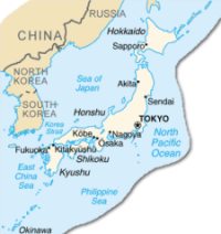
Japan occupies an archipelago off the coast of Eastern Asia. The capital is Tokyo, which, along with neighboring Yokohama, forms the world’s most populous metropolitan region. Japan proper has four main islands, which are (from north to south) Hokkaido, Honshu, Shikoku, and Kyushu. There are many smaller islands stretched in an arc between the Sea of Japan and the East China Sea and the Pacific proper. Honshu, Shikoku, and Kyushu enclose the Inland Sea.
The general features of the four main islands are shapely mountains, sometimes snowcapped, the highest and most famous of which is sacred Mt. Fuji; short rushing rivers; forested slopes; irregular and lovely lakes; and small, rich plains. Mountains, many of them volcanoes, cover two thirds of Japan’s surface, hampering transportation and limiting agriculture. The first European contact with Japan was made by Portuguese sailors in 1542. A small trade with the West developed. NOTE
|
 |
NEW ZEALAND
Perhaps, most famous as "Middle Earth", New Zealand is an island country in the South Pacific Ocean, over 1,000 mi Southeast of Australia. The capital is Wellington; the largest city and leading port is Auckland. New Zealand comprises the North Island and the South Island, Stewart Island, and the Chatham Islands. Small outlying islands belonging to New Zealand include the Auckland Islands, the Kermadec Islands, Campbell Island, the Antipodes, Three Kings Island, Bounty Island, the Snares Islands, and the Solander Islands. Dependencies are Tokelau and Ross Dependency.
North Island is known for its active volcanic mountains and its hot springs. The country's longest river, the Waikato, and largest lake, Taupo, are both on the North Island. On the South Island, the massive Southern Alps extend almost the length of the island, and in the southwest are beautiful fjords. NOTE
- New Zealand Herald:
- CIA World Factbook-New Zealand: An overview of New Zealand's government, economy, population, system of transportation, and military.
- Introduction to New Zealand
- Tourism New Zealand: Learn about the diversity of New Zealand has to offer. Database of tourism industry operators in New Zealand.
- Scenic New Zealand wallpaper for your computer
- New Zealand Government Portal: Find information and services provided by New Zealand government organisations, local councils and community organisations. Managed by the State Services Commission, a New Zealand government department with Maori language specialists from Te Puni Kokiri (Ministry of Maori Development) providing the te reo (Maori language) version.
- New Zealand's House of Representatives
- New Zealand's Ministry of Foreign Affairs & Trade: Info about New Zealand's International relations
- New Zealand Embassy in Washington
- National Library of New Zealand: Kia ora. Nau mai, haere mai ki To Puna Matauranga o Aotearoa
- Ydub: Nau mai! Aotearoa New Zealand site created exclusively by young women, for young women– ki nga wahine rangatahi, mo nga wahine rangatahi. Info on important stuff like having safer sex and liking your body, creative writing, the nz music scene, articles on political issues, advice on budgeting and careers and more.
- KIDS & TEENS
- New Zealand Post Children's Book Awards: Finalists and winners for 2003 in senior fiction, junior fiction, picture-books, & non-fiction.
- Kids Internet Gateway
- FUEL: a youth site from the Alcohol Advisory Council of New Zealand
- LungFish: the Coke Smokefree Rock Quest
- Subvert: Celebrating and promoting the work of young people in the arts, using mainstream media as the canvas to exhibit their work (teens)
SOUTH KOREA
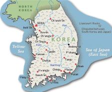
After World War II, a republic was set up in the southern half of the Korean Peninsula while a Communist-style government was installed in the north. The Korean War (1950-53) had US and other UN forces intervene to defend South Korea from North Korean attacks supported by the Chinese. An armistice was signed in 1953 splitting the peninsula along a demilitarized zone at about the 38th parallel. Thereafter, South Korea achieved rapid economic growth, with per capita income rising to roughly 20 times the level of North Korea. South Korea has maintained its commitment to democratize its political processes. http://www.cia.gov/cia/publications/factbook/geos/ks.html
The Republic of Korea is important to world energy markets as the fourth largest oil importer, and the second largest importer of Liquefied Natural Gas (LNG). With no domestic oil reserves, South Korea must import all of its crude oil. Oil makes up the largest share of South Korea's total energy consumption, though its share has been declining in recent years. Coal supplies about 20% of South Korea's total energy requirements. Most of this coal is imported, since the only indigenous coal resources consist of low-quality anthracite used in home heating and small boilers.
|
 |
- CIA: World Factbook-South Korea: An overview of South Korea's government, economy, population, system of transportation, and military.
- The Korean Herald: English-language daily newspaper. Founded in 1953, the "Korean Herald" is published in Seoul by Herald Media Inc., that also publishes "The Herald Business" in Korean and the biweekly English news magazine "Korea Now".
- The Korean Times: Published by one of the largest-circulation newspaper companies in Korea, the Hankook Ilbo (The Korea Daily). Provides in-depth stories about past and present events in Korea, as well as a look into the country's future. Famous for its prompt news flash services of foreign and business news. The Korea Times is the oldest independent English-language daily in Korea - operatng since November 1, 1950.
- The Seoul Daily
- : Korean government's official homepage, korea.net provides a gateway to information about Korea. Timely information about Korea, including translations of the latest reports and analysis released by various departments of the Korean government. The latest local news is also available in the News section. Major news stories in six additional foreign languages: Chinese, Japanese, French, German, Spanish and Vietnamese.
- Korea National Tourism Organization (KNTO): Promotes the Korean tourism industry. Currently, the organization's main activities comprise both domestic and overseas promotion projects designed to expand travel and tourism in Korea.
- South Korea - A Country Study: On-line book. NOTE
- Google's: Kids and Teens > School Time > Social Studies > World Cultures > Asia > Korea
- Google's: Kids and Teens > School Time > Social Studies > World Cultures > Asia > Korea > Korean Food


On-line books published by the Federal Research Division of the Library of Congress.Describes and analyzes a country's political, economic, social, and national security systems and institutions, and examining the interrelationships of those systems and the ways they are shaped by cultural factors - the people who make up the society, their origins, dominant beliefs and values, their common interests and the issues on which they are divided, the nature and extent of their involvement with national institutions, and their attitudes toward each other and toward their social system and political order. (The book represents the analysis of the authors and should not be construed as an expression of an official United States government position, policy, or decision.)
Columbia Encyclopedia, Sixth Edition. © 2002 Columbia University Press.
The North East Digital Village does not knowingly collect information from children under 13.
The North East Digital Village has made an effort to ensure that the pages linked from this section of our pages are suitable for children, but we cannot be responsible for the content of the pages we link. If you believe that a site linked above is unsuitable, or if you would like to suggest an additional site for inclusion, please send mail to us at kidsweb@nedv.net.